Lycian Civilization
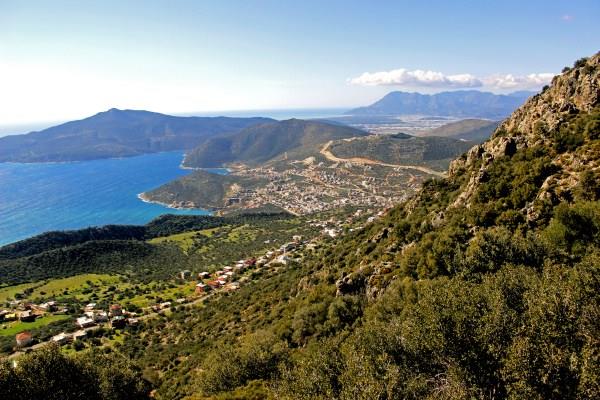
The peninsula, which is today called the Teke Peninsula, extending into the Mediterranean between the Antalya and Fethiye gulfs, was called Lycia in ancient geography. The southern border of the region is determined by the Mediterranean; The eastern, western and northern borders have changed according to periods throughout history. According to ancient writers; The Bey Mountains, the Akdağ range and their extension in the northwest direction, starting from the immediate west of Antalya and extending towards the southwest, constitute the northern border of Lycia. Homer, in his famous Iliad epic describing the Trojan wars, tells that the Lycians sided with the Trojans against the Achaeans under the leadership of Glaukos and Sarpedon. Lycia came under Persian rule with the conquest of the Persian King Harpagos in 545 BC and joined the navy formed by King Xerxes to conquer Greece in 480 with 50 ships. The Persian invasion ended in 334 BC when Alexander the Great of Macedon crossed the Bosphorus and entered Anatolia and defeated the Persians in the Battle of Granicus in 333 BC.
After the death of Alexander the Great, Lycia came under the domination of the Ptolemies, one of his generals who ruled in Egypt from 309 BC, for approximately 100 years, and this period is known as the period when the Lycian language was forgotten and replaced by Greek.
The region was occupied by Syrian King III between 197-167 BC. It is under the rule of Antiochus. Lycia from Rome B.C. He received his freedom in 167. It is known from inscriptions and coins that during this period, 23 cities, including the capital Xanthos, formed the “Lycian Union” and money was minted in the name of the union. Strabo states that the 6 largest cities of the Lycian Union were Xanthos, Patara, Pınara, Olympos, Myra and Tlos.
The Lycian Road Guide Monument, which is a map of the Lycian geography where the settlements are written with connecting routes and distance measurements, is the oldest and only known highway map in the world.
The Union did not lose its function during the Roman Empire Period, and it also reached the highest level of abundance and prosperity during this period. The city population is around 5,000 and the regional population is around 200,000. The borders expanded to include Kaunos (Dalyan) in the northeast. 5. cent. In the mid-1990s, 34 cities were counted under the Consul Governor of the Lycian Province. The region between Demre and Kaş is the most densely settled part of Lycia. There are almost 30 residential areas per km2.
The Lycian people encountered Christianity during their third missionary trip in 53-57, in St. It dates back to Paulus’ visit to Myra and Patara. Methodius of Olympos was the first known bishop of Lycia and was executed in Patara in 312. The Byzantine period in the 4th-7th centuries was the period when Christianity was established in the region and many churches were built.
One of the important changes that started with Byzantium was the emergence of monastery settlements, especially in the mountainous parts of Demre. Monasteries are centers of power so important that they influence economic and public life. Monastic life in Lycia dates back to the 5th century. 5.-6. 5.-6. The construction of many and large churches in the region in the centuries shows that the population of the region was quite high during this period.
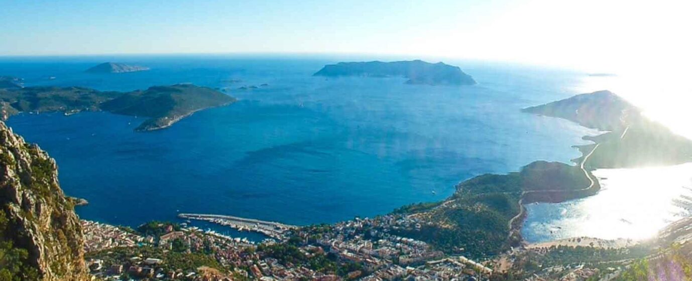
A large part of the Lycian coast consists of rocks. This topography has enabled the formation of ports in some places. Strabo says that the Lycian coasts were rugged and difficult to pass, but their ports were extremely well equipped.
Maritime trade, which has been seen in the region since the Bronze Age, diversified in later periods and continued until the Roman and Byzantine Periods. Purple dye, cedar wood, olive oil, wine and sponge are among the important local production goods of the Lycian region. According to ancient sources, very high quality and soft sponge is mined in Antiphellos and its surroundings. In addition, the quality of Lycian Region cedars used in shipbuilding is very high.
Lycian ports, from east to west, Idyros, Phaselis, Korykos, Olympos, Posidarisus, Melanippe, Gagai, Phoinikos, Andriake, Simena, Teimussa, Aperlai, Antiphellos, Kalamaki, Phoinike, Patara, Pydnai, Arymnessos/Perdikiai, Kalabantia, Karmylessos, Telmessos, Krya , Lissa and Lydai. Among these ports, Andriake and Patara, which host international trade, are distinguished from others by their location and political and economic power.
The region is the most interesting region of Anatolia with its local traditions and especially its unique tomb architectures, and the cities were generally established on the coasts and in the Xanthos and Arykandos valleys, which are considered the heart of the region. Some of the inscriptions belonging to the Lydians, known for their own language and alphabet, have been translated into today’s languages in recent years, most of which belong to tomb inscriptions.
The Lycian region consists of large, medium and small-sized cities, port cities, military and semi-farm and tower settlements. Most of the visible ruins in the region belong to the Roman and Byzantine periods. The ruins that can be seen in the classical settlements concentrated in the mountains are olive oil and wine workshops and agricultural terraces. These rural settlements, which host the majority of the population, feed both themselves and the large cities to which they are connected.
Residential buildings in the Lycian region are generally divided into four groups. First group; Houses lined up side by side on the hill slopes, with separate entrances for each adjacent space. Second group; These are single or two-room houses that are independent of each other in rural settlements within the residential area. Both groups of residences are mostly two-storey, grouped within the city walls or close to each other. Third group; Houses with 2-4 rooms, built scattered in agricultural areas, generally single-storey, some with courtyards, and their own cistern and workshop. Fourth group; These are residences built in rural areas, generally belonging to the rich, with rooms around a courtyard in the middle.
Natural disasters and epidemics occurring in the region have deeply affected cities and lives in cities. The most important of these are the earthquakes that occurred in 141, 240, 385,529 and the plague epidemics in 542 and 1346-1347. Due to the destruction in the coastal areas, settlements in the inner regions have gained importance.
Also, Emperor II. In 655, Constans fought a war against the Arabs on the coast of Phoniks with the navy he commanded. II. Konstans was saved from the defeat they suffered thanks to the sacrifice of a young soldier. After this war in Phoniks, Arab navies began to sail freely along the Mediterranean coast.
In 802, Lycia and Caria regions were captured by the Abbasids. 10. In the 10th century, Lycia and the entire Mediterranean were under Byzantine rule. After 1155, Seljuk II. After Kılıç Arslan defeated the Byzantine armies, Lycia was opened to the Turkmens. After 1204, all of Lycia fell into the hands of the Turks.
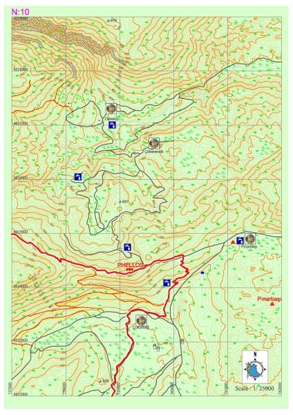
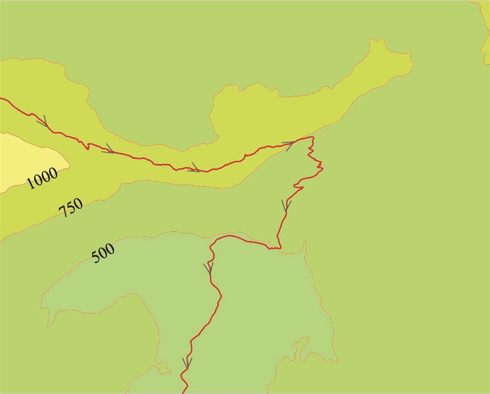
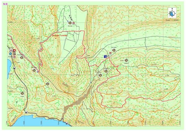
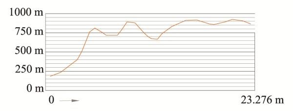
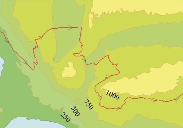
Kalkan-Bezirgan-Sarıbelen
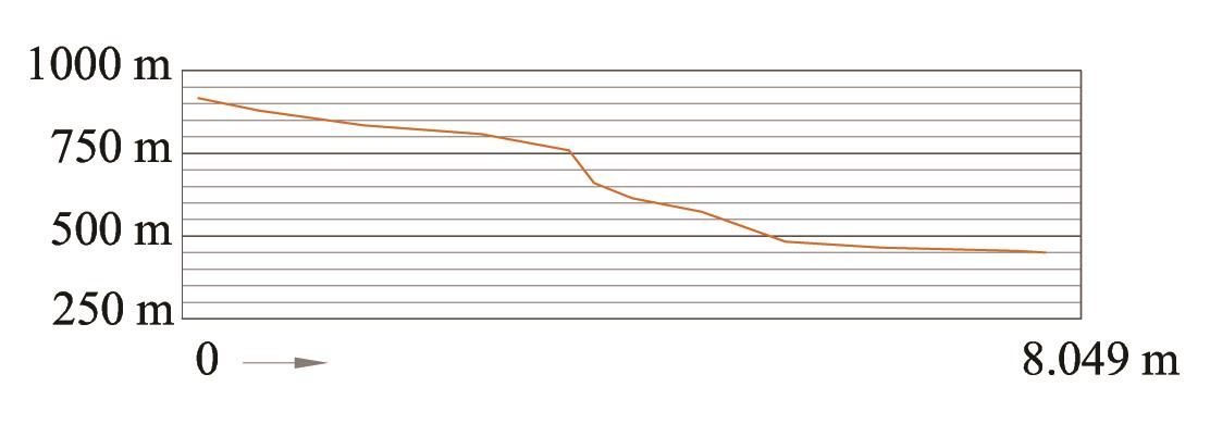
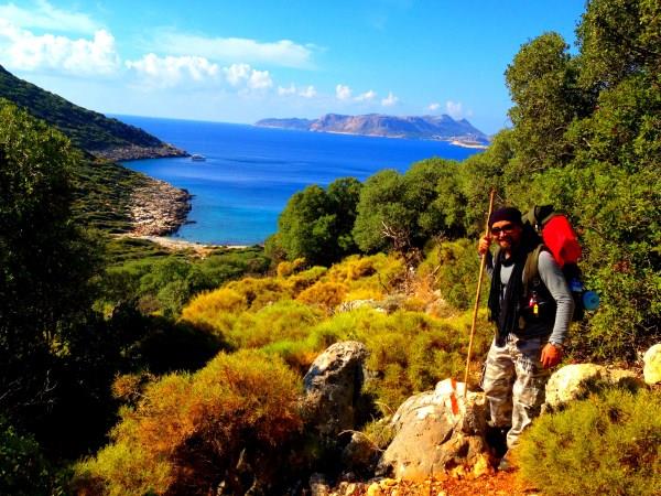
From Akbel to Bezirgan, you can proceed on asphalt for 3-4 km, accompanied by the view of Kalkan. By turning left from the old water cistern on the road, the climb begins by following the stony path in zigzags towards the hill. It can be a steep and tiring climb. After walking along the stony roads after the summit, you can see old but still used grain warehouses. Continue on asphalt until Bezirgan village square. After Kalkan district, drinking water can only be obtained from the fountains in Bezirgan. There is also a market in the center for basic shopping. Leaving Bezirgan, the climb begins towards the main road. After proceeding towards the TV transmitter on the dirt road next to the main road and walking for a while, you cross the dirt road onto the path and start descending through the bushes. In this part, Lycian road signs have been erased in some places. When you go around and land on the asphalt again, you will see the Lycian Way sign. Proceed through the cultivated area towards Sarıbelen. There is a market and also a fountain in Sarıbelen settlement. It is connected to the asphalt again by a path that leaves the asphalt and climbs towards the upper part of the village. After proceeding for a while, continue on the right side of the road, following the path up the hill. After a short forest area, you reach the plain behind Alacaambar hill. The path, which connects to the dirt road, ascends and continues over small hills and plains until Gökçeören, after passing a few plains and sheepfolds.
TUMİNEHI/TYMNESSOS (BEZİRGAN)
Research has shown that the ruins in Bezirgan belong to the settlement called Tuminehi in Lycian sources and Tymnessos in Greek and Roman sources, and that Kalkan was the port of Tuminehi.
Dağ ve tepeler arasında oldukça verimli bir ovaya ve zengin su kaynaklarına sahip Tuminehi, deniz yüzeyinden 1000 m yükseklikte bir dağlık yerleşimdir. The ancient settlement, which has a strategically important location, kept a narrow passage on the main trade route between Xanthos and Phellos under control with a temporary unit located in the castle at the highest point of the settlement. The acropolis is 300 m below this point. It is estimated that the area between these two points, containing the ruins of a church arranged as a high terrace, is the sacred area of the city. The city, located between the acropolis and the passage in question, has been severely damaged due to illegal excavations and erosion.
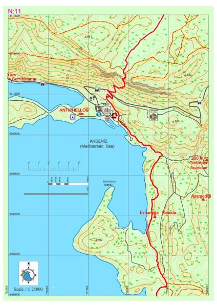
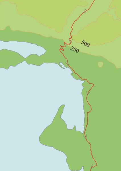
Kaş–Limanağzı
Proceeding south from Çukurbağ, the Lycian Way descends steeply from a terrace overlooking the Kaş district and passes through the Kaş settlement. Kaş district, public transportation, market, bank, accommodation, etc. It is a center where needs can be met. Those who will continue in the direction of Limanağzı should consider that there is no other settlement where their needs will be met until they reach Boğazcık–Kılınçlı settlement. The road continues to Büyük Çakıl Beach on an asphalt road parallel to the sea in Kaş district. After passing the beach, it climbs to the right, into the residential area, and continues on the dirt road from there. Before arriving at Limanağzı location, Sebeda archaeological settlement can be seen; After small side passages with the help of ropes in front of the rock tombs facing the sea, some needs can be met from the businesses in Limanağzı bay. The ongoing path continues through fields, stony areas and narrow dirt tracks, and after a few kilometers from Limanağzı, it heads back to the seashore.
LİMANAĞZI (SEBEDA)
It is known that the name of the city, which includes Bahtsız and Kavgar Hills in the region known as Bayındır Port today, is Sebeda. The city was formed around a reliable port; It is a small farm settlement from the Lycian Period with its sarcophagi, rock tombs, cisterns and oil extraction workshops.
BC on the slopes of Bahtsız Tepe overlooking the sea. Lycian type chamber tombs carved into natural rock dating back to the 4th century; On the seashore, there are building ruins that are thought to have been used as a warehouse and can be associated with the use of a port. On the hill, there is an Open Air Temple, which was created by flattening a natural rock with sarcophagi and niches.
It is estimated that the building ruins on top of Kavgar Hill, which can be reached by a path that was apparently used in the Ancient Period, is a watchtower. Kule çevresinde Likya ve Roma dönemlerine ait, bazıları yazıtlı lahitler bulunmaktadır.
ANTIPHELLOS
The name of Antiphellos, on which the Kaş district center is located today, is mentioned as Habesos in inscriptions written in Lycian language and on coins. B.C. The city, which is known to have existed since the 6th century, was a small settlement in the form of the port of Phellos, located slightly above it, in the early periods. However, as the Hellenistic Period entered, Phellos declined and Antiphellos developed and came to the fore. This situation continued in the Roman Period; The city developed thanks to the trade of cedar trees obtained from the forests of the region and sponge diving, and became a self-sufficient, rich city rather than the port of Phellos; It became one of the member cities of the Lycian Union.
The ancient city is located partly under the present city and partly on the peninsula extending in the east-west direction. Remains of Hellenistic walls showing rectangular stonemasonry can be seen in the part where the peninsula begins, on the side facing Meis Island and on the seaside.
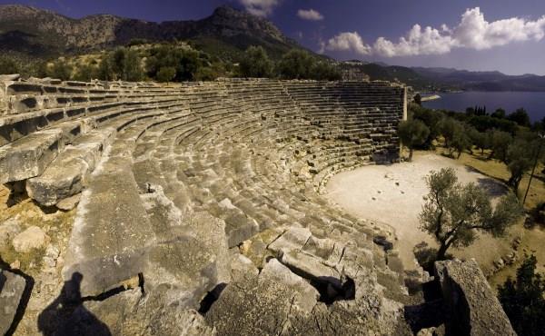
The sea-facing theater of Antiphellos, on the side of the road leading to the Çukurbağ Peninsula, has survived to the present day in good condition. The theater, which has very beautiful stone workmanship with 26 rows of seats on a high place on the peninsula, has typical Hellenistic theater features and does not have a stage building. It was built in the northeast of the theater, carved into the main rock, BC. There is a burial chamber dating back to the 4th century containing 24 small reliefs of women dancing and holding hands.
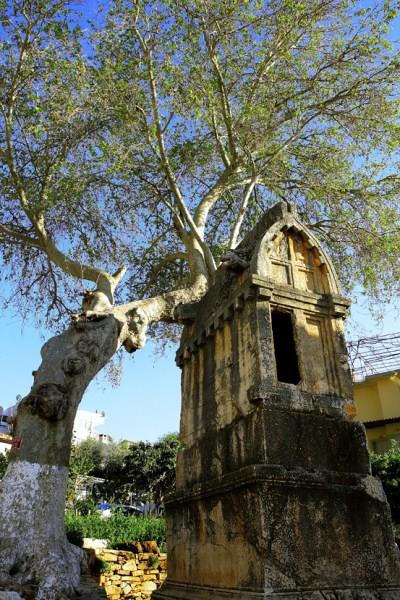
Most of the tombs in Antiphellos are right above and above the houses on the hillside in the north of the city. These tombs constitute beautiful examples of Lycian rock tombs, both with their façade workmanship and inscriptions.
The most important monument of Kaş is the B.C. monument, consisting of a single block, on Uzun Çarşı Street. It is a sarcophagus dated to the 4th century. There are bead motifs and inscriptions on the 150 cm long lower part of the sarcophagus, which has survived to the present day. On the northwestern pediment of the cover, on the left, there are figures of a sad man and a woman, half-dressed, leaning on a stick, with her right leg crossed over her left. On the southeast pediment, on the right, a woman wearing a coat is standing. There are reliefs of a lion between its head and feet on both sides of the cover.
BAYINDIR-ASARGEDİĞİ HILL SETTLEMENT AREA
It is located on the Asargelerini Hill in the residential area to the east of Limanağzı, southwest of Bayındır village in Kaş district. While ascending the slopes from the flat area in the east of the settlement, the first building remains that may belong to a square-planned mausoleum built with smooth cut stones are encountered. The necropolis area, where Lycian type sarcophagi from the Roman Period are located, extends in an east-west direction along the slopes within the settlement, up to the hill. At the top of the hill, there is a defense complex whose walls are supported on the bedrock, built with cut stones in some places and using rubble stones throughout. Detailed information about the plan scheme of the buildings cannot be obtained in the dense vegetation. core/paragraph A trapetum vessel belonging to the workshops is split in half.
Çukurbağ–Pınarbaşı
The road, which follows a sometimes thorny path all the way to Phellos, has become quite unclear in some parts due to new road works. With a slight climb up the hill, the first ruins of Phellos appear and then the path takes us towards the entrance of the city. Before entering the city, it turns towards Çukurbağ. The descent continues steeply for a few kilometers until Çukurbağ. You can enter the village center below from the village mosque. There is no market in the village, but well water can be used in a few places. The Lycian Way, passing through Çukurbağ, passes through long plains and fields and reaches a point overlooking the Kaş district.
As you descend from Phellos towards Çukurbağ, you can see the Pınarbaşı settlement and the ruins registered under the name Pınarbaşı further south, without leaving the road.
PHELLOS
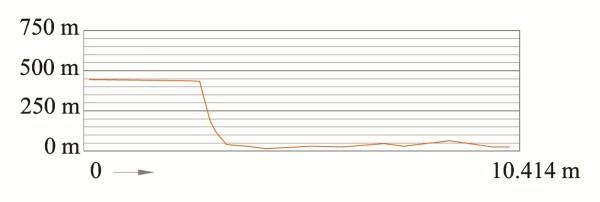
The city of Phellos is located in the northeast of Kaş (Antiphellos), at an altitude of approximately 950 m above sea level, in the Felen locality in Çukurbağ village, on a hill with a length of approximately 550 m and a width of 200 m.
The history of the settlement dates back to B.C. 6-7. It dates back to centuries. Its name in Lycian language is “Vehinda”. Rather than looking like a big city, Phellos is a military settlement that controls the entire region, and Antiphellos is the port of this settlement.
The wealth of the city comes from the income obtained from cedar forests. The walls surrounding the acropolis are supported by towers in the east and southeast directions.
Among the many sarcophagi located in the valley to the north of the acropolis and at the foot of the hill opposite, BC. The relief dated 385-350 is one of the most interesting examples. On one side of this sarcophagus, there is a depiction of the grave owner lying on a couch and holding a glass in his hand. There are two figures standing on either side of the dead body and bird figures under the cedar. In this area, some of which have inscriptions, date back to B.C. There are also other sarcophagi dating back to the 4th century. There is a house-type Lycian rock tomb towards the western end of the acropolis. It is one of the most unique examples of Lycian wooden house architecture reflected in a rock burial, and klines can be seen on three sides of the burial chamber.
PINARBASI RESIDENTIAL AREA
The settlement area is approximately 250 m south of Meşelik Tepe in Pınarbaşı village, and a part of it is approximately 500 m southeast. The first structure encountered is located in a slightly hilly area, with rubble stone walls in a rectangular plan, and is likely to be a tower with lime mortar in the masonry. When you go towards Meşelik Hill from this structure, you can see a well, cistern and ruins of a ruined building whose plan cannot be understood due to dense vegetation. To the west of this ruin, there is a building ruin surrounded by a courtyard wall, with a well and cistern in the courtyard.